

The trail passes through a Calabrian pine forest with beautiful view spots of the Bay of Morfou (central west part of Cyprus). At Selladi tis Straorouthkias, the trail joins with the Kourdali – Limeria trail, and both trails share a common route for the next two kilometres.
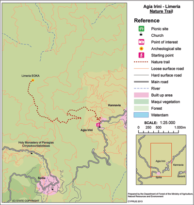
 The trail ends at the location of Limeria with its many hideouts that were used during the anticolonial National struggle war of 1955-1959. Some six kilometres north of Agia Eirini Village there is a picnic site: ‘Kapoura’, which is situated next to the Kapoura Forest Station.
Flora: While hiking you can study the endemic plants: Golden oak (Quercus alnifolia), Thyme (Thymus integer), ‘Manouthkia’ (Pterocephalus multiflorus subsp. multiflorus – an evergreen small shrub with pale pink flowers), Cyprus skullcap (Scutellaria cypria subsp. cypria).
Fauna: The main species found in the area are:
Mammals: Fox, hare, hedgehog.
Birds: Bonelli’s eagle, Eurasian jay, Wood pigeon, Partridge, Cyprus warbler (endemic), Cyprus wheatear (endemic).
Reptiles: Cyprus viper, Cyprus lizard, Black whip snake.
| GPS coordinates of the starting point: | Lat: 34.980599 Lon: 32.968808 |
| GPS coordinates of the ending point: | Lat: 34.990647 Lon: 32.950746 |
| Altitude of the starting point: | 906m |
| Altitude of the highest peak: | 1,217m |
| Altitude of the end peak: | 1,204m |
| Starting point: | Agia Eirini Village. |
| Length: | 5km |
| Estimated duration: | 2.5 hours |
| Difficulty rate: | 3 (steep uphill route) |
Natural trails of Cyprus. Part XIX. Kyparissia forest – Germasogeia dam (linear)


